The Alaska Highway is what some would consider the greatest American road trip. Built in the 1940s after the bombing of Pearl Harbor, it connected the once neglected U.S. Territory to the contiguous United States allowing the U.S. to protect itself from a land invasion from Japan, a possibility that became all to real months later when the Japanese conducted air strikes on U.S. military bases in the Aleutian Islands and established military bases of their own on the islands of Attu and Kiska. In just 8 months time U.S. Army soldiers and civilians carved a 1500 mile route, in some places so narrow and harrowing it could barely be called a road, over the Canadian Rockies, through the Yukon Territory, all the way to remote military outposts in Alaska. Despite being mostly gravel the highway opened to the public in 1948. Over the years the highway improved and in 1992 the paving of it was completed. But if you’re thinking Interstate 5, a major north/south artery from Mexico to Canada, forget it. The Alaska Highway still remains a remote two lane highway subject to extreme weather making sections of it forever rough and always under repair.
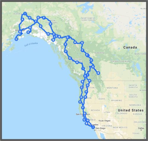
This engineering marvel of WWII is our summer destination, the bucket list item that my husband has been planning for the last 5 years that is now only 38 days away. But this 3000 mile round trip highway is only part of our journey. We start and end here, at home, in Southern California, 2000 miles away from Dawson Creek, BC, the start of the Alaska Highway. Our furthest north point is Fairbanks, AK. Or maybe Homer, AK. I don’t know without checking latitude and longitude. Along the way we’ll —
- Visit family in Oregon and with any luck, friends in Alaska and British Columbia.
- Take a side trip to Jaspar and Banff National Parks and travel the Columbia Icefield that connect the two, a drive Condé Nast Traveller rates as one of the top drives in the world. This is our second visit to Banff, our first being a mid-winter ski vacation. Everything was covered in white then. And the temperatures were below freezing. I can’t wait to see and feel the contrast.
- Wind through the lush farmland of the Peace River Valley in British Columbia,
- Traverse the heart of oil country where we’ll find North America’s largest gas processing plant of one of its largest deposits of shale gas. Parts of our trip even parallel the Trans-Alaska Pipeline.
- Explore Yukon, a Canadian territory of approximately 186,000 sq. miles and only 35,000 people. The territory is twice the size of Great Britain and is the home of the Yukon River, the world’s 5th longest. We ferry across the Yukon River to continue on the Alaska Highway – a ferry I’m told will not look big enough for our travel trailer, but will be. Here is also the heart of the Klondike Gold Rush.
- Re-visit fond memories with friends in Skagway, AK, a town which is along the Alaskan cruise route. I can still picture the cruise ship docked near the narrow gauge railroad, the walk into town, sitting at a table in a park on a lovely sunny day writing postcards, zip lining, and for this non-beer drinker enjoying an Alaskan Amber.
- Celebrate reaching Delta Junction, AK, the end of the Alaska Highway.
- Mail postcards from the town of North Pole and go panning for gold in the town of Chicken, both on the Top of the World Highway in Alaska.
- Fish for Halibut, Salmon, and Greyling; an activity my husband is greatly looking forward to especially in Alaska where he fished once before with his brothers many years ago.
- View (and hopefully photograph!) black and grizzly bears, caribou, elk, moose, bison, eagles and more. The Alaska Highway is also known as a wildlife haven, mostly due to its remoteness.
- Revisit civilization now again with stops in Fairbanks and Anchorage and some of the larger cities on the Alaska Highway such as Whitehorse, Yukon. Get a massage, as my sister-in-law recommended. Maybe treat ourselves to a night in a hotel. Or perhaps we’ll go the other direction and see what it’s like to camp in a Walmart parking lot.
- Head to the coast for some ocean time visiting the Kenai Peninsula and in particular Homer, AK. Here I also plan to visit The Homer Bookstore, a bookstore listed in an article a friend recently sent me called The Best Bookstores in All 50 States.
- Take a jaunt over to Valdez, a stop we added to the itinerary last weekend after reading about the breathtaking views of glaciers, one in which you can drive up to on the road from Fairbanks to Valdez. Two major highways on this route converge on the border of America’s largest national park – Wrangell-St. Elias, a park which holds nine of the 16 tallest peaks in the U.S. It’s apparently the size of 6 Yellowstones, for those of you familiar with the size of Yellowstone.
It adds up to 9000 miles. Some of it on The Alaska Highway, much of it not. And all of it in a 26′ travel trailer. It’s hard to imagine covering that much territory and being away from home long enough to do it. We couldn’t do it without our support team – family and friends and neighbors who are housesitting, cat sitting, taking care of our yard, starting my hybrid car once a month, and just generally being there to help out as needed. It takes a village to travel 9000 miles and we have an amazing village.
Use the interactive map below to see our route. You can zoom in and out or click on a point to see the name of somewhere we plan to stop. To study sections of the trip (this is where the lettering of the points really comes into play), click on the icon to the left of the title “The Alaska Highway”. The trip is set up in sections. The resulting screen lists the stops in each section and here you can hide sections from view using the red checkmarks. Our northbound route is the eastern side of the loop and our southbound the western. If you’re a map person it’ll be fun.


14 comments
Never knew the history behind the building of the Alaska Hwy. As a lover of history, thanks for the information. And, like all of us, so appreciate being able to travel along on your Grand Adventure with you!!
The history is pretty interesting. People compare the building of it to the Panama Canal because of the extreme conditions under which it was built – most notably, the weather,
So glad we can all travel along with you.I’m blown away by your and Mark’s detailed travel plans and look forward to reading about amazing sights ans seeing amazing pictures.
The planning of this has been Mark’s hobby for the past 5 years. I think it helped him get through the last 5 years of work.
What an adventure it will be! And how great that we will all be able to take it along with you thanks to your ability to express yourself through written words and photographs! 38 days and counting until “our” trip begins. I’m not sure that I’ve gone without seeing you for 3 months…at least not in the last 25 years or so. I will miss you!
I’m really going to miss you too.
Can’t wait to follow along with the map and your blog! I will take the trip vicariously and know that because of your wonderful way with words, it will be a great trip! 38 days and counting…not sure if I’ve gone without seeing you for 3 months…at least not in the last 25 years or so. I’ll miss you!
I am looking forward to seeing you when you are in my neck of the woods!
We are going to love every mile of your trip. Posts are great.
Kit
Thank you. That’s my role — documentarian. 😊
Very impressive journey! You mentioned down-sizing. This isn’t permanent is it? What will your butterflies do without you?
The downsize is only in regards to the trailer we’ll be living in for the road trip. Home will be here waiting for us when we return.
WOW! That is quite a trip! Wishing you a safe and happy journey!
Thank you!!